RAUCEBY HOSPITAL
Sleaford, Lincolnshire
HISTORIC LANDSCAPE ASSESSMENT
Alan G Crosby MA DPhil FRHistS
(CPR Consultants)
April 2001
CONTENTS
- 1. Historical development of the landscape
- 2. The present state of the grounds: an historical assessment
- 2.1 General discussion
- 2.2 The driveways
- 2.3 The 'parkland'
- 2.4 The woodland areas north and east of the hospital
- 2.5 The recreation ground
- 2.6 The airing courts
- 2.7 The land at the south-east corner of the site
- 2.8 The chapel and its surroundings
- 3. Conclusions
Introduction
This report was commissioned by Michael Courcier and Partners, town plannign and development consultants of
Bolton, on behalf of their client Capitec. It provides an assessment of the historical landscape around
the former mental hospital at Rauceby, in the context of the current proposals for the partial demolition
and partial conversion of the hospital, primarily for residential use. The asssessment is based on field visits
and site investigation; documentary research usign the original records of the hospital held at Lincolnshire
Archives; secondary sources (particularly the English Heritage report produced by Sarah Rutherford in May 2000);
and conversations with, and the letters of comment or objection made, by representatives of the Lincolnshire
Gardens Trust, English Heritage and the Garden History Society. In producing this report I have sought to give
an objective and realistic assessment of the position, based on my experience as a professional landscape
historian.
1. Historical development of the landscape
1.1 Until the late 18th century the site of Rauceby Hospital was part of the West Field of the parish of
Quarrington, probably occupied by open common grazing land - there is no specific evidence that this part of
the parish was divided into arable strips. The West Field, with other common fields of the parish, was enclosed under
an Act of 1796 and the area later occupied by the hospital was divided into two parts. To the west was an 84 acre
enclosure allotted to the rector of Quarrington in lieu of tithes, while to the east was 255.5 acres allotted to
the lord of the manor, the earl of Bristol. The latter was also awarded, as lay impropriator of the Quarrington
tithes, a parcel of 28.5 acres part of which was later occupied by the hospital. The division between the eastern
and western allotments (those of the earl and the rector respectively) was a long straight boundary running due
north-south. This boundary has now completely disappeared, the two parcels having been amalgamated in the late
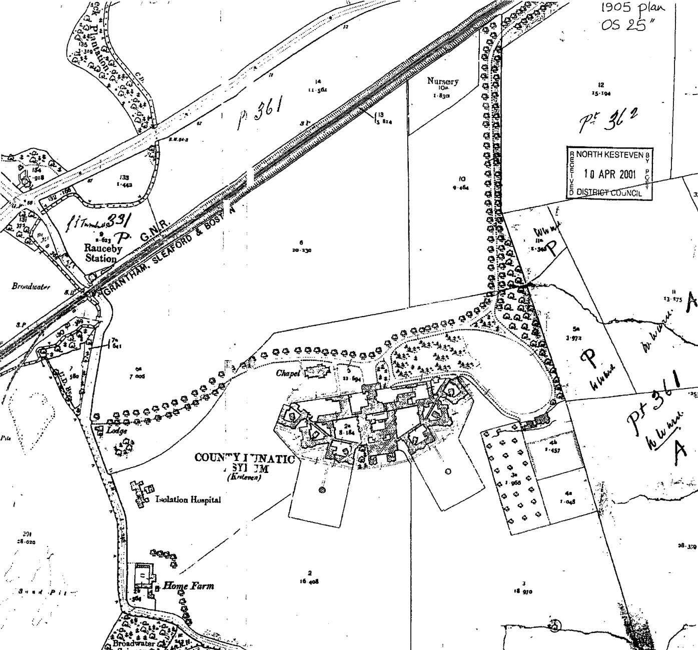
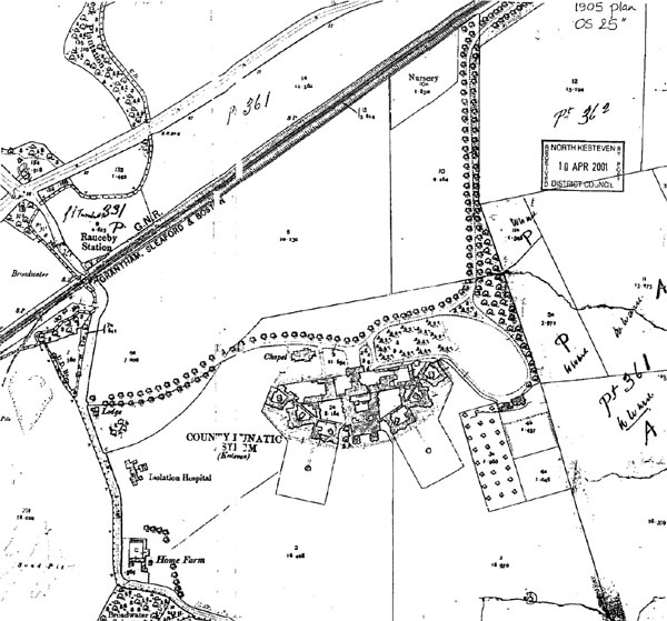
1890s when the County Council bought the land for the asylum. However, it is still shown on the 1905 OS 25-inch
map and on contemporary photographs, by which time it had been interrupted by the building of the asylum as
well as by the construction of the railway line in the late 1850s.
1.2 Part of the boundary of the parcel allotted to the earl as lay impropriator of tithes is followed today
by the straight field boundary on the eastern side of the approach drive from the east lodge and level crossing.
Another field boundary may have run roughly east-west across the land north of the later asylum, this being marked
by a ditch. Some parts of this ditch also survive (for example, on both sides of the modern path from Orchard House
southwards towards the hospital buildings). These features today are the only significant elements of the pre-1890s
landscape to survive in the site. Under the 1796 enclosure award it was proposed to construct a new road directly from the
erstwhile ford on the beck immediately adjacent to the Grantham Road (close to the present railway station) across
the hospital site in a south-easterly direction towards Silk Willoughby. This road was not constructed, although it
is shown as proposed on the 1796 enclosure plan, and instead the present indirect Willoughby Road, which was a
pre-existing trackway running along the parish boundary, was retained and is shown on the 1st edition OS
1-inch map of 1824.
1.3 The land after the beginning of the 19th century seems not to have been considered as particularly valuable
and was let out by successive rectors of Quarrington for grazing. It was regarded as being of poor quality
(frequent references to its inferiority and the difficulties of cultivation are found in the early records of the
hospital) and it was also in an exposed position, another factor which caused problems when landscaping began at the
start of the 20th century. The relatively poverty of the land, its exposed location and the fact that it had been
used for cheap grazing meant noth only that the property was purchasable at low prices, but also that the design
of the landscape could preceed without reference to pre-existing features. The post-1900 gardens are therefore
strikingly free of older controls or influences.
1.4 Kesteven County Council decided in February 1895 to 'provide and maintain a District Asylum for the accommodation
of the Pauper Lunatics of the County' and in January 1896 considered a list of five possible sites. The preferred location
was Barrowby near Grantham but the purchase fell through and eventuall the site at Rauceby, which was clearly not the
ideal one, was chosen. In February 1897 the acquisition of 111 acres was completed at a cost of just over �5,550
(67.5 acres from the rector and 43 acres from the earl of Bristol).
1.5 The design of the buildings and landscaping of the site were a priority. A design competition was held during
1896, the winner being G.T. Hine, and only limited consideration was at this stage given to the laying-out of the
grounds. In August 1896 the Visiting Committee send a small delegation to 'look over the lands with the view to
the boundaries and other parts of the lands being planted with trees', and although no reason for this is noted
it is likely that the main aim was to provide shelter for the bleak and exposed site. This means that the earliest
date for planting was the autumn of 1896, although no detailed plans or specification survive to indicate whether
this happened or in which areas.
1.6 Hine's design for the asylum buildings was amended in detail after site visits and during consultation with the
Committee. The materials to be used were 'red pressed bricks with stone stills and heads and string courses and possibly
some stone for quoins and mullions in the Official Block, and that the roof should be slate.' However, it is clear that
economy and minimising expenditure were as important a determinant of the final form of the buildings as they were
to be of the gardens. Hine wrote in July 1898 that "my endeavour is to keep down the cost of the Asylum in every way possible
without sacrifice to utility or structural stability and I have carefully avoided introducing expensive work for
merely decorative purposes and rely chiefly on a bold outline and fair proportion for architectural effect." This principle,
although expressed in the context of the buildings, was that which was followed by the Committee when they came to implement
William Goldring's design for the garden, modifying them and economising on embellishment.
1.7 Hine's task was limited to the design and layout of the buildings and in his letter of July 1898 he continued: "I do not
propose to do anything in the way of forming or laying out the grounds or airing courts or of road making on the estate beyond the
foundation of main approach to Asylum [sic] which the Contractor will use during the execution of the work, but if you think well
I can provide in the contract for iron fencing for enclosing patients airing courts in the contract for iron fencing positions as
you may require." This evidence demonstrates that the design of the grounds was subsequent to, and separate from, that of the asylum.
The quotation also indicates, however, that the Committee had decided in advance that the grounds would be laid out on the airing
court principle which was well-established in later 19th century asylum design and that the basic assessment of what was required
was possibly presented as a 'design brief.'
1.8 Work on the building was well under way before consideration turned to laying out the grounds. The Committee asked
Robert Lloyd, gardener at the Surrey County Asylum at Brookwood, if he would undertake design work, he having been the
designer employed at the Hill End Asylum, St. Albans. He agreeed by in May 1900, after producing a preliminary plan
(which does not seem to have survived), was forced to withdraw because of ill-health. The Committee then asked
William Goldring (1854-1919), the well-known landscape designer of Kew, at a fee of 4 guineas per day (four times
the sum which Lloyd was to be paid). Goldring undertook the work during August 1900, the plans being shown to the
Visiting Committee at its meeting of 19 September that year. He then viewed the site with the Committeee and made
various alterations at their request. The first moves towards implementation were in Novemebr 1900, when the
layout and costings for the proposed roads were prepared.

1.9 The detailed implementation of the work on the grounds began in the early spring of 1901, with the supply of trees
by Dixons of Chester, the construction of the roads (undertaken by Kesteven County Council contractors) and the supply of
an initial order of 700 yards of iron railings for the airing courts. At the same time work and construction of the farm
buildings at the south-west corner of the site was undertaken during the autumn of 1901 and the spring of 1902. The inner
courts, within the building complex, were levelled and topsoil was provided for them.
1.10 The first patients and staff moved into the asylum in June 1902, but work on the grounds was still in its early
stages. During 1903, the asylum accounts records large purchases of trees, and in October 1902 and April 1903 two entries
note the expenditure of �80 each on the shelters for the airing courts, supplied by Boulton & Paul of Norwich. Although
the laying out of the grounds was clearly significant, the Visiting Committtee paid much more attention to the Home Farm,
its buildings and its stock, noting in April 1904 that 'we view the farm as a source of employment for the inmates more
than as an object of profit' and that 'the land is so varied in quality that it was quite impossible to adopt any
uniform method of tillage or of cultivating it in a way satisfactory for those who are responsible for the management...
the only portion which gave any fairly good results was that cultivated as garden ground under the Medical
Superintendent's own supervision.' In the spring of 1905 the Medical Superintendent was instructed to 'engage two men
to prepare the ground so as to be ready for planting trees in the Autumn', although this was subsequently altered to
allow the employment of six men in total. Trees were still being bought in the early months of 1908, after which point
references to the laying out of the gardens more or less disappear from the minutes and accounts. It is thus apparent
that the work was not completed until at least the summer of 1908.
1.11 The final element in the original development of the garden, one which was not part of Goldring's design
for the grounds or apparently of Hine's for the buildings [since it is not shown on the Goldring plan], ws the
construction of the greenhouse or conservatory attached to the central section of the buildings, facing southwards
onto the recreation ground. This was discussed in 1912 and 1913 and initially met with the opposition of the
Commissioners for Lunacy, who objected to its design and location, but eventually in January 1914 agreement was
reached. The greenhouse was built in June and July 1914, but Foster & Pearson, at a cost of �351 5s.
1.12 The Annual Reports of the Asylum, which survive from 1898, give a further picture of the development of the
site in the years before the First World War and include a small number of photographs giving valuable indications
of the progress of the landscaping. The 4th report (1900) states that "The advice of Mr. W. Goldring, a Landscape
Gardener, who has had considerable experience in work of this nature, has been obtailed as to the planting and laying
out of the grounds. The fruit trees are planted, and a nursery of timber and other trees has been formed, as Mr.
Goldrigh advised this would be the cheapest and best way of obtaining the necessary trees for planting out." This
nursery is shown on the OS 25-inch map of 1905, occupying the acute angle between the eastern driver and the railway
line at the north-east corner of the site.
1.13 The 1904 report notes that the Committee proposed to lay out the grounds "gradually year by year, and to
defray the cost out of the profit derived from patients received under Contracts with other authorities." The report also
emphasises the therapeutic benefits of gardening and farm work for the male patients. In reporting on the grounds,
it states that "a considerable amount of levelling has been again accomplished, and many shrubs and trees planted,
but the cold winds and the early drought prevented the evergreen varieties from making a start, and most of these unfortunately,
especially on the north side, are dead." The following year it was reported that "the planting and layout out of
the Asylum Grounds is being steadily proceeded with, and it will be of interest to know that the trees now being planted
were purchased at a small cost
1.14 The Annual Reports also print in full the reports made by the the visiting Commissioners in Luncay, who usually
confined their attention to the buildings, patients and regime but sometimes also give opinions on the state of the
grounds. In 1910, for example, they reported that "it would be well if the borders of the Airing Courts were kept
trimmer, and the Courts themselves somewhat enlarged, and divided up, so as to keep apart the turbulent, the aged and
the feeble; the dirty and degraded and the convalescent patients. There being only one Airing Court on each side,
all classes of patients of each sex, have to use the same Court." It seems probably that as a result of this instruction
the inner northern corners of the two courts were divided off the rest, with railings and hedges, to form the smaller
square self-contained compartments which still survive but which were not part of the original plan. These small units
can therefore probably be dated to 1911-1912. It is certain that they are not original features, not only because
they are not shown on the 1905 OS 25-inch map but because the original perimeter paths of the airing courts
are abruptly truncated by the smaller enclosures which were laid out across the alignments of the existing paths.
1.15 After 1914 there is little indication of significant changes to the grounds of the hospital for twenty years,
although it is necessary to point out that annual reports for 1915-1925 no longer exist among the hospital
records at Lincolnshire Archives. In 1936 work began on the large new complex of buildings north of the hospital
and south of the railway line, which were to provide a self-contained Admissions Unit and office space. The land to
the west of the hospital was at the same time remodelled in connection with the new Nurses' Home and other ancillary
buildings. In this way much of the open ground around the original complex was redeveloped. Goldring's plan of 1900
had left both these areas as farmland (labelled "pasture and grazing land" and "grazing land"). Although his
designed included groups of tress dotted among the grassland there is no evidence that such planting was carried
out. In the late 1930s, however, extensive planting was undertaking to landscape the surroundings of the new buildings,
including a shelter belt to screen the nurses' home from the Home Farm; planting between the Admissions Unit and
the older buildings; and an orachard on the south side of the Admissions Unit. In 1939, elm disease occasioned the felling
of many trees on the site, and the opportunity was taken to replace these with Lombardy poplars, which were also used
to line the roads and pathways in the vicinity of the new buildings.
1.16 During the Second World War the hospital was requisitioned by the RAF and experienced a major period of neglect -
it was noted in 1943 that "much reinstatement will have to be undertaken when the buildings... are handed ack
to the Committee" - and the quality of grounds maintenance also deteriorated during this period. After the war a large
new estate of staff houses was built on the land between the late 1930s Admission Unit and the railway, further reducing
the area of open space which had been shown on the Goldring plan. In the 1950s and 1960s extensions were made to the
original (Hine) buildings, in appropriate materials, while in several areas new hard surfacing and walling in breeze
blocks and concrete paving slabs were introduced, thus compromising the integrity of the original landscaping.
In its final years the unkeep of the grounds was given relatively low priority, features such as the greenhouse
and shelters began to deteriorate, and the raison d'etre of the design was lost as new regimes and principles of care,
in which "airing courts" and outdoor shelters played little part, were introduced. Substantial aressa had become
overgrown with large shrubs and secondary woodland and the orchards were abandoned. Finally in 1997 the hospital closed
and since then no maintenance work has been undertaken on the grounds to the south of the hospital buildings.
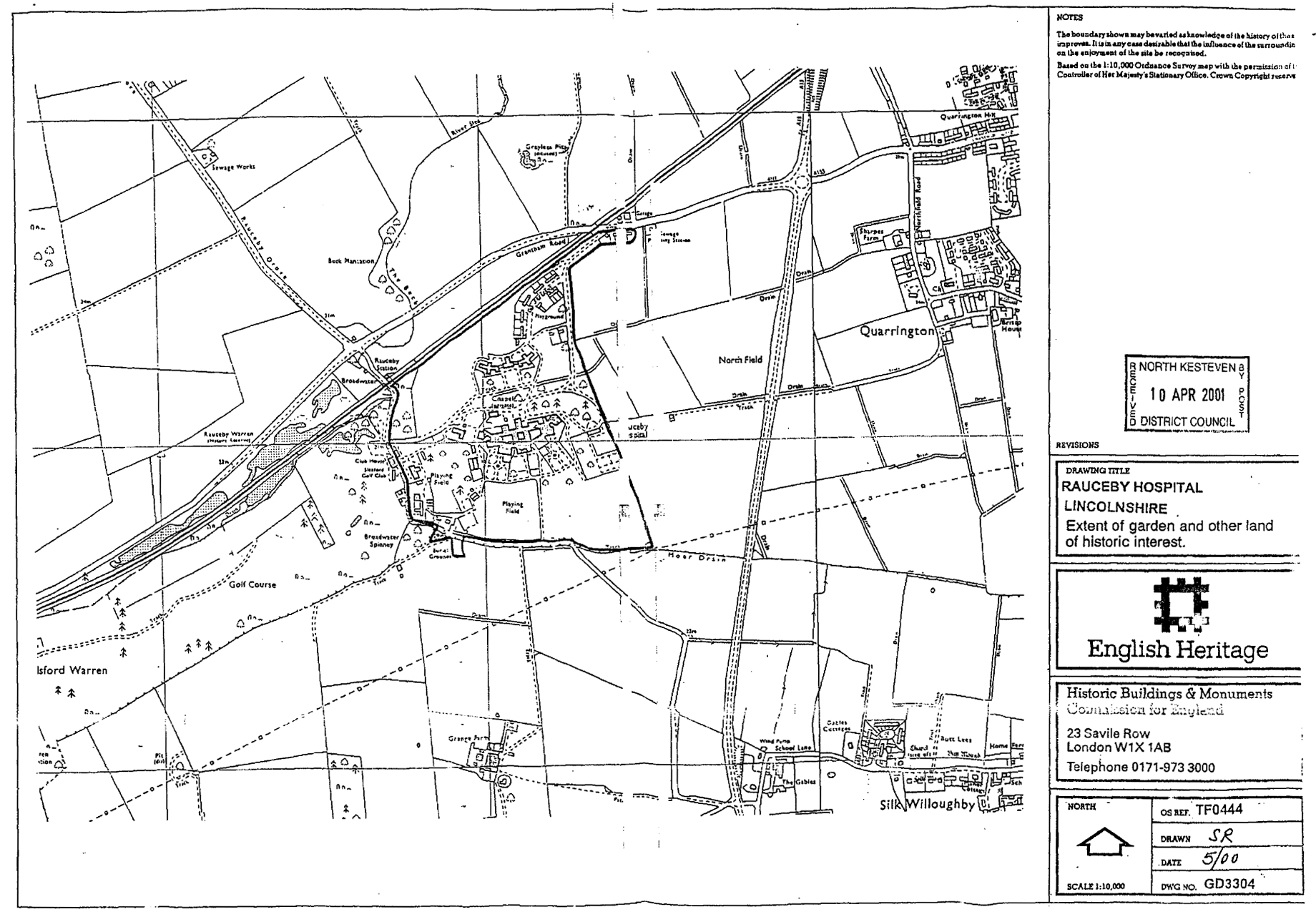
2. The present state of the grounds: a historical assessment
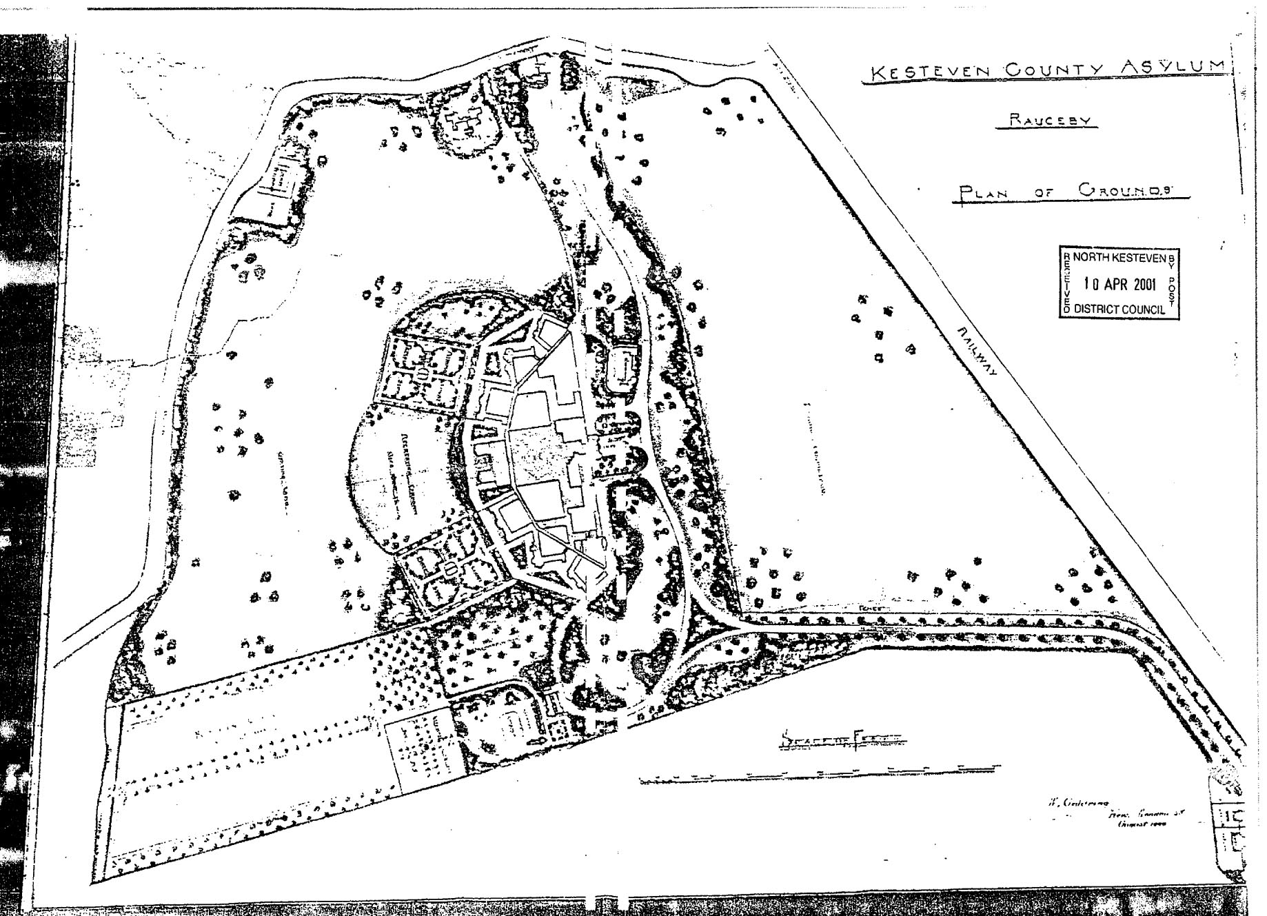
2.1 The original of William Goldring's plan of 1900 is now framed on the wall in the entrance hall of Orchard House.
It is important to acknowledge that the Goldring design was not fully implemented and was already being modified
while laying-out of the grounds proceeded in the years after 1900 - indeed, the evidence of the minutes of the
Visiting Committee in the autumn of that year suggests that from the outset they did not accept the plan in full.
It involves the following major components, which are considered in more detail in the ensuing paragraphs:
i) Gwo long curving approach drives, the eastern one lined with regularly-spaced formally planted trees, the
western one running through grassed areas edged with shelter belts and dotted with small groups of trees.
ii) The northern drive dividing at a triangular junction, the eastern arm curving through grassed and wooded
areas to the Medical Superintendent's house and then continuing to rejoin the other drives at the front of the hospital.
iii) The hospital complex and formally landscapped grounds are closed to the east centre of the site, and the areas to the norht,
west and south were to be laid to grass, used as pasture and grazing, and dotted with small groups of trees.
iv) Shelter and screening belts of planting were to be placed along the public road to the west and south of the site,
and along the alignment of the pre-existing ditch east-west across the centre of the site, just north of the hospital
buildings.
v) The Home Farm and isolation hospital, closed to the Willoughby Road, were also to be screened by planting.
vi) The general principle governing these areas was that of creating a parkland aspect, informal in appearance
and softening the essentially bare and bleak landscape with carefully-placed grounds and borders of trees and
shrubs [Goldring does not, on the plan at least, specify species or types]; this planting would help to shelter
the hospital and also to provide a screen from public view.
vii) In contrast, the area immediately south of the hospital buildings would be laid out in a formal design which
was also to be functional, using as its model the prevailing theories of management of the mentally ill
as exemplified by a succession of drawing-board and realised instituional landscape designs.
viii) At the centre of the southern aspect Goldring placed a "recreation ground", which was to be a grassed area
of about 2.25 acres, apron-shaped with an outward curving southern edge. At each of its four corners was to be a small
group of trees, but otherwise the area would be unplanted.
ix) To the west and east of the recreation area there were to be rectangular "airing courts", with a cross-shape of
pathways dividing each into four quarters. At the centre of each, in the middle of a small square space, was to
be a shelter. The four quarters were to be edged with formal planting, their rectangularity modified by triangular
approaches to each of the pathways.
x) Between the eastern airing court and the Medical Superintendent's House, Goldring proposed an orchard area,
edged by belts of denser planting along the drive and the path which followed the south side of the asylum
buildings.
xi) To the south east of the formal grounds the Goldring plan shows a huge rectangular kitchen garden, at its maximum
extent over 1000 feet in length, with sub-compartments and divisions by walks and lines of formal planting,
and with another orchard within its curtilage.
xii) On the north side of the hospital buildings the main administration building would be fronted by two oval
planted plots, and a rectangular turning area, while the chapel was to be closely encircled by planting and thus
completely screened.
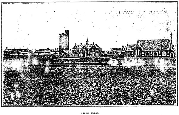
The north front of the Kesteven County Asylum, circa 1903, showing the absence of landscaping acround the
recently completed buildings. Across the middle distance runs the line of the older ditch which still survives
though heavily overgrown, while in the foreground the parkland is apparently being used for growing crops.
2.2 The driveways
2.2.1 These were cearly constructed according to the layout shown on the Goldring plan, although the western driveway
and access from the Willoughby Road is currently blocked and becoming somewhat overgrown. The character of the two
routes is markedly different, the eastern one (the present approach) being more formal and the western one more
irregular, as conceived by Goldring. The aspect of the eatern drive has been substantially altered, however, byt
the development on its west side before and after the Second World War. Its eastern aspect (towards Sleaford) remains
largely as Goldring seems to have intended.
2.2.2 I note that the plan currently proposed makes substantial changes to the alignment of the northern drive;
while this may be considered necessary on traffic grounds it is very impornant that any alterations have minimum
impact upon the alignments of the existing roads, particularly in the vicinity of the triangular junction north-east
of the hospital buildings. If sections of the two driveways are to be superseded, it is essential that their alignments
should be retained as pathways or woodland walks, and that their maintenance as formal elements of the overall landscape
design is continued.
2.2 The "Parkland"
2.3.1 There is no evidence that the "parkland" as designed by Goldring was laid out. The areas in question, north and
south of the main buildings and designed grounds, were used as pasture and grazing land but successive OS maps imply
that the grounds of trees which are indicated in the 1900 plan were not planted. The early photographs of the
nroth front shown that the field north of the drainage ditch, where Orchard House is today, was planted with what
may be cabbages, while an aerial photograph of 1940 (taken after the new buildings had been completed) suggests that
grassland had been continous across the entire area south of the railway and north of the ditch.
2.3.2 At the southern end of the site, the parkland should have stretched as far as the Willoughby Road but clearly
never did, and this area is now divided into fields of conventional type. Part is now occupied by a derelict orchard
and part by the massively-overgrown L-shaped laurel, privet and cupressus hedge which enclosed the west and north-west
corners of the orchard. A line of relatively recent silver birch cuts across the field south of this hedge, again without
any relationship to the Goldring plan.
2.3.3. The western stretch of parkland, running south from the western drive, has disappeared under the building developments
of the 1930s and 1960s. It is therefore apparent that not only was the outer area of the Goldring plan largely
unimplemented, but that subsequent modifications have totally altered the character of most of the land in question.
This is reflected in the exclusion of these parts of the site from the conservation area. The current proposals,
for the conversion and partial demolition of the hospital buildings, do not impinge upon these areas significantly,
with the exception of the alteration in the alignment of the eastern driveway, the replacement for which would cross
park of the park north of the site. As noted above, such large-scale cahnges should be avoided if at all possible.
2.4 The woodland areas north and north-east of the hospital
2.4.1 The 1900 plan suggests that the original concept for the landscaping north of the hospital was a variation on
a parkland theme, with grassed areas edged by a screen or shelter belt and dotted with individual trees or small
groups. The major exception would be the area around the Chapel, which would be more densely-planted. It is
questionable whether the plan was implemented in detal, although it is certain that extensive planting was undertaken
in these areas.
2.4.2 The 1905 OS 25-inch map marks a line of formal planting alongside the western drive and the meting of the
two drives immediately north of the main hospital entrance, in a way not envisaged by Goldring. It also marks planting
in the oval area north-east of the main entrance, and indicates that this was significantly more dense than the
planting which Goldring had proposed. The 1940 aerial photograph confirms that interpretation, since it shows very
clearly that the area south of the drive and north-east of the buildings was then thickly-wooded with substantial trees.
Today this area is grassed, with groups of laurels, and with the overgrown alignment of a (1960s?) concrete block
path which curves in an arc from the corner of the drive, across the slope, and then back to the wire-fenced enclosure
at the north-eastern corner of the main buildings. This slope is very wet with substantial natural seepage and much
of it is waterlogged. The present landscape is likely to have been created by major tree-felling and redesign in the
1950s or 1960s.
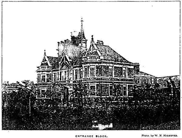
The entrance block of the Kesteven County Asylum, circa 1905, showing the dense planting of trees and shrubs
in the oval to the west of the main entrance. This area is now very densely-grown over. The picture also
illustrates the way in whcih at this time, before later building alterations took place, the main entrance
block was more prominent and isolated.
2.4.3 To the east of this area, in the large oval north of the former Medical Superintendent's House, and in the broad belt
of land south of Orchard House, there is now dense, unmanaged and heavily overgrown woodland, which bears no resemblance to the
landscape which is shown on the Goldring plan. The woodland has encroached upon the footpath on the north side of the drives,
almost burying it, and it is cut through by the pathway from Orchard House to the hospital, which was laid out in 1939
when the new buildings were constructed. This path, then edged by newly-planted poplars, is shown on the 1940 aerial photograph.
2.4.4 The present proposals envisage the retention of most of this woodland, but it is likely that substantial upgrading and
a policy towards long-term management will be essential. There are also significant drainage problems in parts of the woodland -
although 'wet woodland' is quite acceptable in ecological and landscape terms, the run-off from the slopes north of the
Medical Superintendent's House, and adjacent to the 1950s/1960s grass and laurels area, runs across the approach drives. It likely
to represent a continuing problem and therefore a management programme for this woodland would ideally include some
drainage works (perhaps associated with pond creation?).
2.5 The recreation ground
2.5.1 This was the central element (in the geographical sense) of the formal design for the land south of the main buildings. Here,
as in other asylums, the rationale was that of the therapeutic benefits to the patients of exercise, fresh air and recreation,
so we should interpret the different components of the design as being justified more by the practical or utilitarian value than by
notions of pure aesthetics - the latter clearly played a part, but were not the primary impetus to the design. The recreation ground
was not constructed an envisaged by Goldring. It was laid out after 1905 (it is not shown on the 25-inch OS map of that year)
and some time after the airing courts on either side had been set out, which perhaps suggests that it was not regarded as being
important. Goldring's idea of a 'scalloped' or convex southern edge was not implemented. There is no trace on the ground of any
perimeter bank, ditch or other enclosing feature and the present straight edge seems to be original.
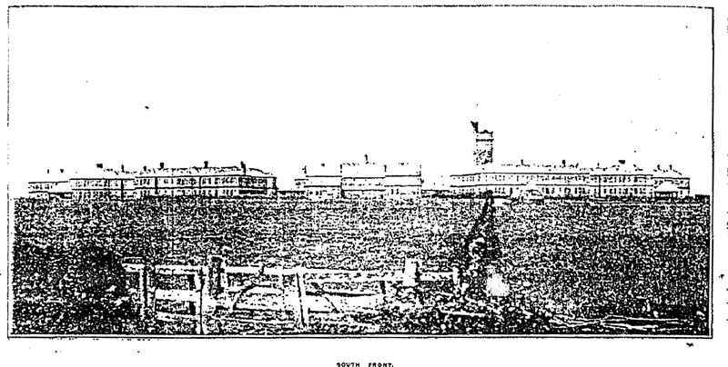
The south front of the Kesteven County Asylum, circa 1903, before landscaping work on the grounds had moved
into the central area. To the left and right can be seen the newly built shelters (erected 1902-1903) and
work on the airing courts has apparently just begun. The long hedge which is running from the buildings
directly towards the camera is the boundary between the eastern and western sections of the 1796 enclosure
allotments.
2.5.2 The photograph of the south front of the buildings which is reproduced in the 1906 Annual Report also demonstrates that
Goldring's design had been abandoned in another way. Whereas his 1900 plan shows open grassland, with a small group of trees at each
corner, the 1906 photograph shows that a long straight cnetral path had been constructed at right angles to the buildings, edged by newly-planted
saplings and bushes. Substantial numbers of trees had also been planted, as early as 1906, across the areas of grass to either side,
and the grass itself was not cut or mown. This strongly suggests that the present wooded aspect of this area was being envisaged from
an early date. The central path, thickly crowded by the trees planted in 1906 which are now tall and mature, and by the dense shrub planting
of the same date, is still the key feature of the recreation ground area.
2.5.3 The 1940 aerial photograph shows that on either side of this path there were rectangular lawns edged with trees and bushes,
while on the western lawn, and possibly the eastern one as well (the photograph is difficult to interpret with total confidence) there was
a rectangular enclosure which seems to have been railed off and is edged with some small bushes. At the northern end of hte central path the
conservatory was constructed in 1914, and immediately outside it an oval bed was created and planted with shrubs. This is a prominent feature
on the 1940 image but is not part of the 1900 design.
2.5.4 Today the outer parts of the recreation ground are heavily wooded: it is apparent that maintenance has been poor for many years and
much secondary growth has occured, while one of the trees has recently blown over. The former lawned areas are themselves fast-disappearing under the
scrub, and the area also includes two huts or sheds of temporary and unattractive appearance. Within the western lawn it is possible to
identify the faint lines of part of the enclosure which is shown on the 1940 photograph, and on both lawns the southern edge of the enclosures
is marked with a shallow bank and depression.
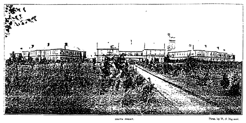
The south front of the Kesteven County Asylum, circa 1905, showing the newly-laid out "recreation area"
with central pathway at right angles to the south front: extensive planting of trees and shrubs across the
area which the 1900 plan had been intended as grassland; and the long uncut grass.
2.5.5 The overall assessment of the recreation ground is therefore that from the beginning it was not laid out
as Goldring had envisaged, that it quickly became sub-divided by tree-planting and eventually partly
obscured by woodland and shrubbery, and that today, as during most of the past century, it bears little
resemblance to the proposed landscape shown on the 1900 plan.
2.5.6 A key feature of this section of the grounds is the conservatory which, as noted above, was not part of
the original design of either the building or the grounds. It was built in 1914, twelve years after the opening
of the asylum, forteen years after Goldring's paln was produced, and sixteen years after the architect's plans
were drawn up. The conservatory is of red brick to a waist level with a decorative band of blue brick near
ground level, in keeping with the design of the original building, and a glazed and wooden structure above with
a clerestory and wooden finials. It is now derelict and was de-listed in 1996. It is, however, potentially of
considerable interest in terms of the new garden design and its retention is now being considered (earlier plans
having involved its demolition). Whilst I do not feel able to comment in any detail on the current proposals,
I do feel strongly that it should be retained if at all possible and given a new role within the plan for the
interface between the housing areas and the grounds. Its siting is clearly related to the alignment of the central
tree-lined pathway which runs southwards across the "recreation area" and to the oval bed at its northern end,
and these three elements together would make an important and strong feature of the refurbished grounds.
2.5.7 Given that Goldring's design for the recreation ground was not implemented, and that subsequent changes
were also made, the proposals seem very acceptable (comments in 2.5.6 being noted), but it is essential that
a comprehensive programme of clearance of secondary growth, restoration of the lawned areas, management of the
woodlands, and demolition of the temporary huts and other structures should be included within any landscape
strategy. I reiterate that the central pathway, suitably managed and upgraded, and the oval bed at its northern
end, should form the focal element in the design for this part of the site in the future, together with very
careful consideration of re-opening the views through to the "parkland" to the south, including the provision
of iron fencing along the field boundary.
2.6 The airing courts
2.6.1 The western and eastern airing courts are the best preserved parts of the formal Goldring design. As noted
above, each was modified, probably in the years before the First World War, by the construction of a subsidiary
enclosure in the north-east and north-west corners respectively, while the building of post-war extensions
to the hospital buildings also impinged upon the airing courts. The irregular spaces between the northern
edges of the courts and the hospital buildings was also altered by the introduction of concrete paving,
low breeze-block walling and other non-traditional features, although their basic form remained unchanged.
It is clear that these spaces were a weak part of the overall design (the parts with penetrated towards the
interior of the building complex were heavily shaded and blank) and the integration between buildings and
grounds was perhaps least successful here.
2.6.2 The courts themselves were surrounded with plain iron fencing, the gateways and corners being
ornamented with more substantial uprights topped with small finials. Long stretches of this fencing
survive, although usually in poor condition. In places, especially on the eastern court, fallen uprights
lie on the ground. The later subsidiary enclosures were also edged with this type of fencing. The southern
edges of both courts have long since lost their railings, apparently in the 1930s when a more "open"
recreational regime was introduced, but the low banks on which the railings stood may still be traced
alongside the tarmac path. In the design for the redevelopment of the site, where the courts are most
commendably to be retained as enclosed open space, it is very important that the replacement of the railings
at the southern ends of both courts should allow views through to the fields beyond, to maintain the "parkland"
vistas which were clearly part of the design concept. It would also be appropriate if the replacement fence
conformed closely to the design of the original.
2.6.3. Goldring's design suggested that each quadrant of the courts should be edged with planting,
but there is no real indication that this proposal was carried out as he intended (although faint earthworks
in some places do imply that there were some beds or planted areas, and the remains of of a small rows of
shrubs can be seen on the north-west side of the central space in the western court). The 1940 aerial photograph
does...
[pages missing]
...battered state today. One area of orchard lies immediately south of the eastern airing court, projecting
out into the field acorss the area which under Goldring's design was intended to be "parkland", while
other orchards occupy the ground south and west of the garden of the Medical Superintendent's House. These
orchards are not within the present application site but it would be particularly desirable that, in any
future proposals, efforts should be made to retain the fruit trees whenever possible. The evidence on the
ground (literally!) indicates that some of the trees still fruit heavily.
2.8 The chapel and its surroundings
2.8.1. The Goldring plan shows the chapel surrounded by dense planting, with a small churchyard
[i.e. not a burial ground] immediately encircling the building and the only access being a short
path or drive leading from the north-west corner of the hospital buildings. This is shown - but
without the surrounding planting - on the 1905 OS 25-inch map, but the 1940 aerial photograph
confirms that the planting of the area between chapel and hospital had indeed taken place, since
substantial trees on shown on that view [sic]. After 1950, however, the entire surrounding area was
dramatically altered in appearance by the felling of almost all the trees, and the laying out of hard
surfaced car parking across the whole of the area south and east of the chapel. In addition, possibly
in the 1960s or 1970s, a somewhat unappealing area of crazy paving and lwo walls was constructed
about 20 meters south of the chapel, along the edge of the drive, embellished with low concrete walls,
a rustic wishing well in stone and concrete blocks, two circular beds edged with low kerbs of stone
setts, and six round planters constructed of setts and concrete.
2.8.2. The present proposals involve the retention of part of the car park, but with a much
improved formal design, and allow for the area around the chapel itself to be landscaped. If this
was done with a "Victorian shrubbery" theme I feel that it would represent a major enhancement of this
area and greatly improve the setting of the chapel. In a letter from the Garden History Society to
North Kesteven DC (9 January 2001) comparison is made between the plans for this area and those indicated
on the Goldring plan and it is suggested that the proposals run counter to his intention, but given
the fact that in the past half centure almost of traces of Goldring's design have been eliminated...
[rest of document missing]
 Return to: Rauceby Virtual Asylum Return to: Rauceby Virtual Asylum
|